1/8
GPS Fields Area Measure screenshot 0
GPS Fields Area Measure screenshot 1
GPS Fields Area Measure screenshot 2
GPS Fields Area Measure screenshot 3
GPS Fields Area Measure screenshot 4
GPS Fields Area Measure screenshot 5
GPS Fields Area Measure screenshot 6
GPS Fields Area Measure screenshot 7
GPS Fields Area Measure Icon

GPS Fields Area Measure

Studio Noframe
Trustable Ranking Iconمورد اعتماد
51K+دانلودها
38MBاندازه
Android Version Icon5.1+
إصدار الأندرويد
3.14.5(04-03-2024)آخرین نسخه
4.8
(6 دیدگاه‌ها)
Age ratingPEGI-3
نحوه نصب
1
فایل نصب را دانلود و باز کنید
2
Unblock AptoideAptoide is a safe app! Just tap on More details and then on Install anyway.
3
نصب را کامل کنید و Aptoide را باز کنید
app-card-icon
جزییاتدیدگاه‌هانسخه‌هاالمعلومات
1/8

توضیحات GPS Fields Area Measure

Easy to use, useful app for an area, distance and perimeter management.

This tool is helping for million people to measure their fields, mark their needed points and sharing their measured maps with their colleagues.


Don't waste your time searching for the best free app to measure area, distance and perimeter - choose our app and simplify the measuring process!


UNIQUE FEATURES:


➜ Fast area/distance marking


➜ Smart Marker Mode for very accurate pin placement


➜ Name, save, group and edit measurements


➜ “Undo” button for all actions


➜ GPS tracking/Auto measure for walking/driving around specific boundaries


It also includes a feature to send an auto-generated link to your friends or partners of pinned/selected area, direction or route – displays the area you want to share.


A feature to add the point of interest or POI on the field helps to avoid stones, mark fences or boundaries of paddocks, graze territories for dairy cows, cattle, beef and other livestock.


In need for more advanced versions?:


❖ PRO version


https://goo.gl/Gh5Jp6


❖ Ad-free version


https://goo.gl/S0u7f1


Try out our other apps for farmers:


❖ Field Navigator


https://goo.gl/hZBnJI


❖ AgroBASE


https://goo.gl/1v0bFt


❖ Soil Sampler


https://goo.gl/6vHwrF


❖ Commodity Spy


https://goo.gl/1f72jm


❖ Calcagro


https://goo.gl/a1jKeM


Disclaimer: Subscription is not included in ad-free or PRO versions, it is an additional feature obtained by an in-app purchase. The mentioned versions influence and expand functionality.

* The app perfectly works with a GARMIN GLO and GARMIN GLO 2 external GPS antennas.


Download it and start measuring your fields today!


GPS Field Area Measure is also useful as a map measurement tool for outdoor activities, range finder applications and sports such as biking or marathon. Comes in handy when exploring golf area or as a golf distance meter, convenient for land surveys, practical for field pasture area measure, helpful in garden and farm work or planning, great to keep area records. It’s great for constructions and agricultural fencing. This application is practical even for solar panel installation, roof area estimation or trip planning.


Our measuring app has the highest accuracy in the market, that being the main reason why we’re the leading measuring app among construction sites, building and farm contractors and farmers.


Among our users are people constructing roofs, buildings and roads, farm owners who are spraying, fertilizing, seeding, harvesting farms or tilling. It’s helpful for biking, traveling or planning trips. For growing gardens and paddock, grass or lawn – we are the number one choice.


Including people who are farming beef, pork, or poultry – the application comes in handy for fence measuring and planning. Pilots can also use this app while flying in the fields. Farm managers and contractors who are exploiting agricultural work for farmers can use this app to count the amount of planted fields and share them with the owner. The fields are displayed in Google Maps.


It's a great tool for paddock calculation and measuring.


This is the best solution for farm owners who grow wheat, corn, rapeseed, maize, sugar beet and need to measure the planted area annually.


All in all, it is useful for:


- Farmers, for farm management

- Agronomists

- Town planners

- Construction surveyor

- Landscape artists

- Land based surveys

- Land record management

- Construction surveys

- Health, Education and facilities mapping

- Farm fencing

- Sports track measurement

- Construction sites and building sites area

- Asset mapping

- Landscape design

- GIS, ArcGIS, ArcMap

آسان برای استفاده ، برنامه مفید برای یک منطقه ، مدیریت از راه دور و محیط.

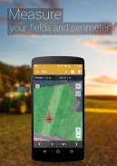
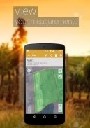
این ابزار به میلیونها نفر کمک می کند تا زمینه های خود را اندازه گیری کنند ، نقاط مورد نیاز خود را علامت گذاری کنند و نقشه های اندازه گیری شده خود را با همکاران خود به اشتراک بگذارند.


وقت خود را در جستجوی بهترین برنامه رایگان برای اندازه گیری مساحت ، مسافت و محیط تلف نکنید - برنامه ما را انتخاب کنید و فرایند اندازه گیری را ساده کنید!


ویژگی های منحصر به فرد:


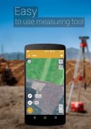
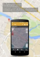
area علامت گذاری به مساحت / فاصله سریع


er حالت نشانگر هوشمند برای قرار دادن پین بسیار دقیق


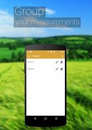
اندازه گیری ها را نامگذاری ، ذخیره ، گروه بندی و ویرایش کنید


button دکمه "خنثیسازی" برای همه اقدامات


➜ ردیابی GPS / اندازه گیری خودکار برای پیاده روی / رانندگی در مرزهای خاص


این همچنین شامل یک ویژگی برای ارسال یک پیوند خودکار ایجاد شده به دوستان یا شرکای منطقه پین ​​شده / منتخب ، جهت یا مسیر شماست - منطقه ای را که می خواهید به اشتراک بگذارید نشان می دهد.


یک ویژگی برای افزودن نقطه مورد علاقه یا POI در مزرعه کمک می کند تا از سنگ ، علامت نرده ها و مرزهای کله پاچه ها ، چرای زمین برای گاوهای شیری ، گاو ، گوشت گاو و سایر دام ها جلوگیری کنید.


به نسخه های پیشرفته تری نیاز دارید ؟:


❖ نسخه PRO


https://goo.gl/Gh5Jp6


version نسخه بدون آگهی


https://goo.gl/S0u7f1


برنامه های دیگر ما را برای کشاورزان امتحان کنید:


❖ ناوبری زمینه


https://goo.gl/hZBnJI


❖ AgroBASE


https://goo.gl/1v0bFt


Sam نمونه خاک


https://goo.gl/6vHwrF


❖ جاسوس کالا


https://goo.gl/1f72jm


❖ کالکاگو


https://goo.gl/a1jKeM


سلب مسئولیت: اشتراك در نسخه های بدون آگهی یا PRO گنجانده نشده است ، این یك ویژگی اضافی است كه با خرید درون برنامه ای بدست می آید. نسخه های ذکر شده بر عملکرد و گسترش آن تأثیر می گذارند.

* برنامه کاملا با آنتن های GARMIN GLO و GARMIN GLO 2 خارجی GPS کار می کند.


آن را بارگیری و شروع به اندازه گیری زمینه های خود از امروز!


اندازه گیری زمینه های GPS همچنین به عنوان ابزاری برای اندازه گیری نقشه برای فعالیت در فضای باز ، برنامه های کاربردی یاب و دامنه ورزشی از جمله دوچرخه سواری یا ماراتن مفید است. در هنگام گشت و گذار در منطقه گلف یا به عنوان یک متر فاصله از گلف ، مناسب برای نظرسنجی از زمین ، عملی برای اندازه گیری سطح مرتع مزرعه ، مفید در کار و برنامه ریزی در باغ و مزرعه ، مفید برای نگه داشتن سوابق منطقه مفید است. برای ساخت و سازها و نرده های کشاورزی بسیار مناسب است. این برنامه حتی برای نصب پانل های خورشیدی ، تخمین مساحت سقف یا برنامه ریزی سفر عملی است.


برنامه اندازه گیری ما دارای بالاترین دقت در بازار است ، به همین دلیل اصلی ترین برنامه اندازه گیری پیشرو در بین اماکن ساختمانی ، پیمانکاران ساختمان و مزرعه و کشاورزان هستیم.


در میان کاربران ما افرادی هستند که بام ، ساختمان و راه را می سازند ، صاحبان مزرعه که سم پاشی می کنند ، کود می کنند ، بذر می کنند ، مزارع را برداشت می کنند یا در حال زراعت هستند. برای دوچرخه سواری ، مسافرت یا برنامه ریزی سفر مفید است. برای رشد باغ ها و گاو ، چمنزار یا چمن - ما انتخاب شماره یک هستیم.


از جمله افرادی که در حال پرورش گوشت گاو ، گوشت خوک یا مرغ هستند - این برنامه برای اندازه گیری و برنامه ریزی حصار مفید است. خلبانان همچنین می توانند هنگام پرواز در مزارع از این برنامه استفاده کنند. مدیران مزرعه و پیمانکارانی که در حال بهره برداری از کار کشاورزی برای کشاورزان هستند می توانند از این برنامه برای شمارش میزان مزارع کاشته شده و به اشتراک گذاری آنها با مالک استفاده کنند. زمینه ها در Google Maps نمایش داده می شوند.


این یک ابزار عالی برای محاسبه و اندازه گیری پدوک است.


این بهترین راه حل برای صاحبان مزرعه هایی است که گندم ، ذرت ، کلزا ، ذرت ، چغندرقند رشد می کنند و نیاز به اندازه گیری سطح زیر کشت سالانه دارند.


در کل ، برای موارد زیر مفید است:


- کشاورزان ، برای مدیریت مزرعه

- زراعت شناس

- برنامه ریزان شهر

- نقشه بردار ساخت و ساز

- هنرمندان منظره

- نظرسنجی مبتنی بر زمین

- مدیریت ثبت زمین

- بررسی های ساختمانی

- نقشه برداری بهداشت ، آموزش و امکانات

- شمشیربازی مزرعه

- اندازه گیری آهنگ ورزشی

- سایت های ساخت و ساز و منطقه سایت های ساختمانی

- نقشه برداری دارایی

- طراحی منظره

- GIS ، ArcGIS ، ArcMap


GPS Fields Area Measure - نسخه 3.14.5

(04-03-2024)
سایر نسخه‌ها
تازه‌هاAddress search is now free.

هنوز هیچ دیدگاه و نظری وجود ندارد! برای ثبت اولین دیدگاه لطفا روی کلیک کنید.

-
6 Reviews
5
4
3
2
1
Info Trust Icon
گارانتی اپلیکیشن خوباین اپلیکیشن تست‌ امنیتی برای ویروس، مالور و سایر حملات خطرناک را گذرانده است و دربرگیرنده هیچ خطری نیست.

GPS Fields Area Measure - اطلاعات APK

نسخه APK: 3.14.5حزمة: lt.noframe.fieldsareameasure
سازگاری با اندروید: 5.1+ (Lollipop)
برنامه‌نویس:Studio Noframeشرایط حریم‌خصوصی:http://legal.gpsmeasure.comمجوزها:25
نام: GPS Fields Area Measureاندازه: 38 MBدانلودها: 12Kنسخه : 3.14.5تاریخ انتشار: 2024-03-04 12:19:54حداقل صفحه‌نمایش: SMALLپردازشگر پشتیبانی‌شده: x86, x86-64, armeabi-v7a, arm64-v8a
شناسه بسته: lt.noframe.fieldsareameasureامضای SHA1: 30:DD:FA:00:46:73:3A:A6:60:5B:F9:47:B7:BE:C0:F4:FC:39:FB:CEبرنامه‌نویس (CN): Remigijus Pakstysسازمان (O): NoFrameمنطقه (L): Kaunasکشور (C): LTاستان/شهر (ST):

آخرین نسخه GPS Fields Area Measure

3.14.5Trust Icon Versions
4/3/2024
12K دانلودها38 MB اندازه

سایر نسخه‌ها

3.14.4Trust Icon Versions
3/11/2023
12K دانلودها38 MB اندازه
3.14.3Trust Icon Versions
13/10/2023
12K دانلودها43.5 MB اندازه
3.14.1Trust Icon Versions
19/9/2023
12K دانلودها42.5 MB اندازه
3.13.3Trust Icon Versions
7/7/2023
12K دانلودها36.5 MB اندازه
3.13.2Trust Icon Versions
19/6/2023
12K دانلودها36.5 MB اندازه
3.13.1Trust Icon Versions
16/2/2023
12K دانلودها35 MB اندازه
3.12.0Trust Icon Versions
31/10/2022
12K دانلودها34.5 MB اندازه
3.11.15Trust Icon Versions
11/5/2022
12K دانلودها33.5 MB اندازه
3.11.14Trust Icon Versions
15/4/2022
12K دانلودها33.5 MB اندازه

اپلیکیشن‌ها در دسته مشابه

شاید دوست داشته باشید...